Did you know that a quarter of people in the UK feel that a 15 minute walk is too far and they will take the car instead?
Wow. 15 minutes is too far to walk?!
And… when 2,000 people from the UK took part in a survey, only 40% of them could put London in the right place on a map. Yea, London. Even fewer knew where Oxford or Aberystwyth are.
Oh my goodness. Please tell me you know where London is on a map?!

From the OS geography survey. Very interesting.
I learnt these things a couple of weeks ago when I was visiting at Ordnance Survey, the super British mapping organisation. I let out an audible “oh dear” when I saw the Peak District image, it absolutely shocked me that people who live in the UK didn’t know where some key UK places are. And really made me rethink laziness when I found out a lot of people won’t walk more than half a mile. Maybe I’m not a couch potato after all? Wow.
Anyway, less about my shock and disappointment at a huge number of my fellow countrymen (hopefully not you…), and more about what I was actually doing in Southampton…

A tree in the New Forest – naturally after half an day in the OS office we had to get outside.
I was invited to spend the day with the lovely people from Ordnance Survey because, well, I’m a bit of an outdoor loving gal, and having grown up using OS maps almost every weekend I wasn’t going to turn down an opportunity to see how the maps are made. I have friends in Southampton and so it was also a good opportunity for a carvery, so it was a win, win.
After Steph from OS had finished shocking me with the above facts, she took us on a tour which took us through the whole map making process from data capture right through to cartography. First we saw how each of 240 field surveyors across the UK use GPS devices mounted on poles to plot features, and how they are uploaded on the spot to the OS mapping database, which they like to have up to date within six months or less, and accurate to within just a couple of centimetres. To help with the accuracy, OS have a series of fixed points in the UK that help them with their calculations – this used to be the famous trig point network that we all know and love, but is now much more sophisticated with a series of small white balls that give of a fixed GPS signal they can work to.
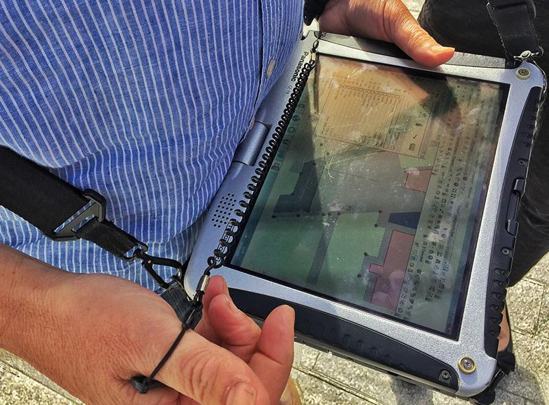
A field surveying demonstration.
This data is supplemented with remote sensing, done in the main by a couple of aeroplanes that fly out of East Midlands airport with an 196 megapixel camera that flies in circuits at 8,000 feet snapping images of the ground. Each year they fly a third of the country, in very methodical lines, taking hundreds of photographs that are then used back at HQ.

OS remote sensing maps.
I totally geeked out on the whole process, I found it completely fascinating, especially when it came to demonstrating how the data from the field surveyors and the aerial photography is turned into maps. There are people who take the data and turn it into usable imagery, people who turn those images into line drawings showing all the useful features, people who add the height information for the contour lines, and people who then turn all that data into the iconic maps hikers and others use every day. All the layers of information mean we have Landranger and Explorer maps great for helping people like me to explore the countryside, and it also provides all kinds of businesses and organisations information they can use for all kinds of purposes.
Oh, and if you were wondering – OS no longer have a room full of 1,000 cartographers hand drawing their maps anymore, it’s all done digitally these days. And this means that when you purchase an OS map in store, you are getting one that is up to date (within six months). And when you use the new OS Maps app, you’re using mapping that is up to date to within three months. Should I mention that Google is sometimes three years out of date?! Maybe I shouldn’t.

Using an OS map to plan a route. Nothing beats it.
All the geeky fun aside, as you will gather from my opening to this blog post, it was the get outside stuff that really caught my attention. I am constantly banging on about the fact we should spend time outdoors every day – it’s good for our body, mind and soul. For example, did you know that most everyday sleep problems are caused by a lack of natural light? And as someone who sits in an office all day with no idea what the weather is doing outside, this definitely made me think. You don’t have to buy a new OS map and head off into the wilderness to climb a mountain, you can simply leave your own front door and walk in any direction for 20 minutes to see what’s there.
To help us heed the advice, we had a fabulous walk in the New Forest in the afternoon, while we checked out the new OS Maps app. More on the app another day as I’ve since been able to put it to the test in Snowdon and other places.

The New Forest.
Do yourself a favour and spend some time outside this weekend… walk for more than 15 minutes, breathe in some fresh air and soak up some Vitamin D. And have a look at a map so you know where London, Aberystwyth and the Peak District are. Then next time Ordnance Survey ask, we can show them we’ve improved.
And please come back here in a week when I’ll be setting you all a get outside challenge for November… it’ll be fun, I promise!
It was great to meet Kate from The Adventures of Kate and Roger from I Run Offroad who joined me for the day, please go and check out their outdoor focused blogs. And don’t forget to check out the OS Get Outside blog for loads of map reading tips and information on how to get more time outdoors.
What do you think? Comment below...