In this weekly blog episode, let’s talk about week, and a fantastic hike along Cat’s Back to Hay Bluff in the Black Mountains.
Ah, back to writing on a Sunday afternoon. I’m sat in my lounge with the sun shining through the patio doors – it’s rather lovely, I have to say. Not quite warm enough to have the doors open to let the fresh air fill the room, but hopefully it won’t be long. Do you think this is the weather making a turn towards better times for a little while? Would be nice, wouldn’t it?!

Apparently in some places in the UK, there have only been six days without rain since 1 January 2024. Which I can well believe. Although I can’t recall where I read that, I do know it has been horrendous! And it’s really taken its toll – on the ground and on me. At least there have been some real signs of spring this week; after Storm Kathleen and her warm winds last weekend, it has felt warmer and more springlike most days this week. Yes, it has rained, but not all day every day. Long may that continue.
I even managed to get out for a hike on Saturday. And I didn’t need wear my beanie hat, gloves or waterproof coat! I chose to hike up Black Hill (Cat’s Back) on the edge of the Black Mountains on the England/Wales border. It was one from my list of hills I can (sometimes) just about make out on the horizon from home – I’m slowly working my way through them all.
More on my Cat’s Back hike in a moment, but first, let’s catch up on the rest of the week…

My Week
I always seem to have a paragraph or two in my weekly blog episodes in which I reflect on how busy life has been, and how long my to do list is. The old chestnut of productivity versus success plays a regular role in my journal writing. But this week, it somehow feels like I’ve got things together for a change. Well, I’ve at least felt a little more in control of my to do list than normal.
Finding Focus
One thing that has helped me find some focus has been classical music. I know, not exactly ground-breaking, but hear me out. I always have music playing at home, but it’s normally out loud, playing quietly in the background. What’s different is that I’ve started to use my headphones, even at home, which seems to make everything else around me feel less distracting.
Having music playing directly into my ears has been helping me focus on the task in hand, and appears to be making it harder to get side-tracked on things I see or remember. As a result, I’ve had some quality writing time, finding flow much easier than normal, both for work and for me. It’s been rather nice.
I’ve also found my other chores have taken less time to complete, because I’m doing those in my breaks rather than using them as my procrastination. Weird. I rather hope this isn’t a one-off thing and will become a long-term focus technique. We’ll see.

Otters in Cheltenham?!
It’s probably also helped that the slightly warmer and more spring-like weather has made my lunchtime One Hour Outsides an absolute pleasure. Getting outside in the middle of the day is a top tip to help make the afternoons productive, that’s for sure.
I’ve found some real moments of tranquillity in getting outside this week. The simple pleasures of feeling the sun’s warmth, hearing the birds singing, and even squelching in the mud when I picked the wrong walk, was a balm to the soul, a gentle reminder of life’s simple joys.
It was reported on the BBC this week that there have been sights of a family of otters living in the lake in Pittville Park, in the centre of Cheltenham. They’ve even been seen out in the daytime, which is somewhat unusual. I spend many lunchtime One Hour Outsides in Pittville Park (you know I visit the rabbits often!), and this definitely gives me another reason to get some fresh air in the middle of the working day.
You may not know, but otters are one of my favourite animals, and I have often gone on otter-hunting missions. But never in a local pond! I’ve already been to have a look for these elusive yet incredibly cute creatures; no luck yet, but I will be visiting often and will report back.
I’m hoping they’ll be easier to spot than the hard-to-find King Fisher – I’ve seen him twice in six years!
Anyway, this is will certainly be the subject for a future weekly blog episode… I guess watch this space for some (probably terrible) photos. Do let me know if you manage to see them yourself.

On the Dinner Table
What’s been on your dinner table this week? I hope you’ve had some delicious meals to enjoy. Eating food is the best way to round off each day, if you ask me!
We started the week with those amazing lamb and feta burgers I mentioned in my last weekly blog episode with homemade wedges and coleslaw, I made some cheesy bean quesadillas which we had with salad, a stir fry with noodles, and a spring chicken one-pot which was a very tasty make-once-eat-twice dinner. It’s probably not been the heathiest of weeks food-wise (apart from the one-pot, that had LOADS of fresh green veggies in it), but life is all about balance.
I still need to sort my meal plan for the coming week, but know it will involve using the slow cooker as I have some long days in the diary. I love my slow cooker – I have the Crockpot Turbo Express (here at Currys, here at Amazon) – and it really is the best way to make sure we eat well even when the days are full. Maybe I’ll make a chilli, maybe a mushroom hot-pot, not sure what else. Feel free to send me your favourite slow cooker recipes!

Happy Trig Week!
This week is trig week. Running from XXX to XXX 2024, Ordnance Survey have dedicated it as an opportunity to commemorate the anniversary of the first trig pillars. And it’s the perfect inspiration for a One Hour Outside in the coming days.
The trig pillar was first used in the triangulation of Great Britain on 18 April 1936, when a group of surveyors gathered around a white concrete pillar in a field in Cold Ashby (there’s more on the history in this interesting article). No longer needed for mapping, they are now popular destinations for hikers looking for inspiration and motivation to get out.
Generally found at high points in a landscape, so surveyors could see one from another, these days they provide an iconic acknowledgement that you have reached the highest point on any walk (but only if you touch it, of course!). They’re not always at the summit, and not all hills have one (and some are on private land or have fallen into disrepair), but trig pillars do often mean good views.
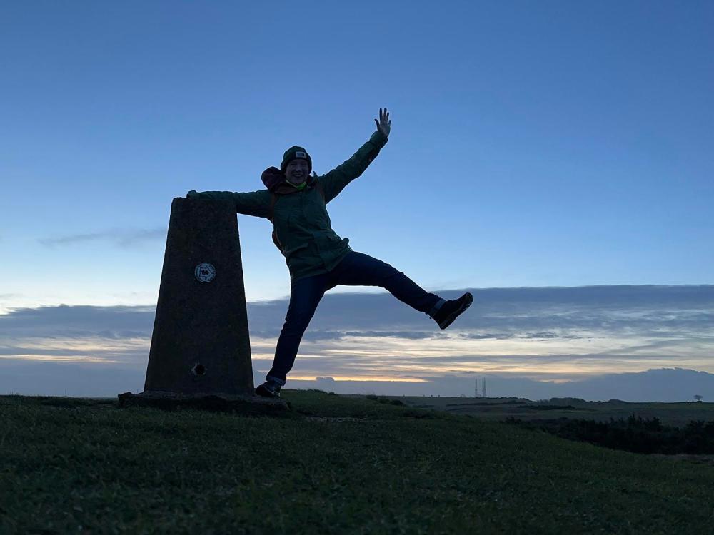
Trig Bagging
Trig pillars really have become part of the way many of us explore Great Britain’s landscapes. From the rolling hills of the Cotswolds to the rugged peaks of the Lake District, there are trig points to be found in every corner of the country. And with so many different routes and trails to choose from – there are still around 6,000 trig pillars left – you could say there is a trig pillar for everyone.
I don’t consider myself a trig bagger – I’ve never kept a list of the ones I’ve reached. But I do look at trigs as a great reward for a good day out. I have been known to create walking routes that purposefully take in a trig or two, and will detour from other planned hiking routes because there is one to see ‘just over there a bit’.

How to Find Trig Pillars
This time last year, Ordnance Survey added a new feature on the desktop version of OS Maps, so you can easily find your nearest trig pillar without having to hunt on the map for the little blue triangles.
Start by opening up OS Maps on your desktop. Click the top icon at the bottom right of your screen, which allows you to display a bunch of useful places, including trig pillars.
You can zoom in to find the exact location, and click on each trig pillar icon to see the name and height of it. You can then plot your own route from your chosen starting point, or use the ‘find routes’ feature to have someone else do the work for you.
This feature is only available on the desktop version, but as I do all my route planning on a computer anyway – and I’m sure most people do – it’s a really cool feature to play with.
If you are not already subscribed to OS Maps, I’d highly recommend it. I’d love it if you would use my affiliate link to sign up – which gives me a little bit of commission (at no charge to you). Thanks!

Hiking Black Hill (Cat’s Back) and Hay Bluff
Talking of OS Maps (nice transition Zoe…), I made very good use of it on Saturday. Hiking along the Cat’s Back ridgeline has been on my list for a long while – and given that the forecasters promised nice weather, it was time to get this one ticked off the to-hike list.
Nestled in the heart of the English countryside, Black Hill sits just on the English side of the England/Wales border on the eastern edge of the Black Mountains. The walk up and along this beautiful but gnarly hill, affectionately known as Cat’s Back, is one of those short hikes with big satisfaction I talk about being my favourite.
And seeing as it was only a couple of miles further along the same ridge, I hiked over to Hay Bluff, just over the border into Wales, and returned to my car via a short section of the iconic Offa’s Dyke Path National Trail.

Cat’s Back
My day started with an early morning drive to Black Hill Car Park (OS Grid Reference SO 28838 32879, or here on Google Maps), which is found deep in rural Herefordshire along a very narrow, winding and undulating country lane (you know, the sort with grass growing up the middle). I arrived around 8.15am, having not met anyone else driving along the road, and was the second car in the small parking area. Things would look very different when I returned four hours later, this is not a secret beauty spot!
With my boots on and OS Maps set to track my activity, the first order of business was a very steep ascent up one end of Black Hill to get to Cat’s Back. There was messing around – the path goes straight up the side of the grassy hillside, which was very muddy in places. It wasn’t technically difficult, or very long, but it certainly got the blood pumping and the lungs working. At least the hard bit was all done within the first few minutes of hiking; the rest of the day’s ascent would be nice and gentle in terms of gradient.
It was then a little over a mile along the beautiful Cat’s Back ridge to Black Hill trig pillar, which stands at 640 metres above sea level and would be my first of two trigs that day. It was absolutely glorious walking; a combination of grassy footpath and boulder-field, with stunning 360-degree views to soak up.

Not too Pointy
I’ve heard some people refer to Cat’s Back as a knife-edge ridge, which it really isn’t. Yes, it’s narrow-ish in places, but it’s not something you’ll be teetering along; there’s lots of room. What it is, is a really beautiful and easy going walk, well worth the initial effort. There are some rocky bits where you need to put some extra effort into your step, but there’s no scrambling along the main route.
This isn’t somewhere I’d want to be in bad weather – it’s incredibly exposed and there is nowhere to hide without a mad dash down into the valley. But while the views were a bit hazy for me, meaning it wasn’t possible to pick out my own local hill on this occasion, it was nothing short of magnificent up there.
And being early meant that apart from one other couple I overtook early on in the hike, I had the whole ridge to myself – which was exactly what I’d hoped for. The day was off to an excellent start.

Hay Bluff
With Cat’s Back hiked, Black Hill trig bagged, and a few swigs of tea drunk, I continued along the ridge toward Hay Bluff (Penybegwm). The ground along this section – and for the rest of the day – was very boggy. I was wearing my Meindl Bhutan hiking boots so wasn’t worried about my feet, but the boggy terrain made things a bit hard going, it was hard to keep up any real pace.
I crossed Offa’s Dyke Path, and now in Wales, walked a short distance across the wild landscape to bag my second trig pillar of the day. Hay Bluff stands at 677 metres, so just a little taller than the one at the end of Cat’s Back – with a lovely red Welsh dragon painted on it. Although the swamp around it was a little too deep for my liking, and so no real trig selfie this time.
I was also able to see one of the mysterious monoliths that have been appearing in apparently random places in the countryside. This three-metre-high triangular post made of stainless steel looks as though it must have either grown out of the saturated bog or been dropped from the sky. It’s quite a sight – standing proud in the bog in the otherwise featureless landscape. To be honest, I had to Google it (and found this BBC News article), and it turns out this thing has only been there a month. No-one knows what it’s for or who put it there.
I kind of like it – it reflects the landscape, but definitely isn’t of the landscape. It was clearly put there by aliens… what other explanation is there?! Oh, and it certainly looks better than the random traffic cone I saw later on the same hike.

Offa’s Dyke and A Non-Existent Footpath
I retraced my steps a short distance back to where I’d crossed Offa’s Dyke Path, this time turning right to head south along Offa’s Dyke for a bit. And despite what came next, I was so glad I did. With England on the left, Wales on the right, I bounded along the almost-completely-flagged path on top of the hill – with lovely views all around. I would love to hike the Offa’s Dyke Path in full one day, I really fancy that.
The weather was gradually closing in, as the forecasters had suggested it would, but there was no sign of rain and the cloud stayed high enough for me to have decent visibility in all directions.
To get me back to my car, I’d chosen a footpath marked on the OS Map that took me diagonally across the hill and then steeply down it, almost in a straight line from Offa’s Dyle Path down to Upper Blean. Now this turned out to be something of a mistake; the path just wasn’t there on the ground, or at least I couldn’t see it. I gave it a go anyway, using OS Maps on my phone, as well as the paper copy I had in my pack, to walk as close to the green dotted line as I could.

Following the Green Dots
My route ended up quite wiggly, but I reckon I did a pretty good job navigating that stretch. I was able to pick out a reasonable-enough route between patches of heather and moss, avoiding the really boggy bits as much as possible. I guess I just thought that at some point I would come across the actual path, and all would be well. Maybe when I got the steep descent?
No. Well, kind of. I could see where I was meant to end up, thanks to a kissing gate into a meadow that looked to be exactly on the green dotted line down in the valley. But I really struggled to work out how I was meant to get there. It was so very steep, much steeper than the climb up to Cat’s Back, and I found it incredibly strenuous, and a little unnerving in places if I’m honest. I did my best to follow the line as marked on the map, which meant hugging a brook cascading down the hill over some rocks.
Thankfully, although not without a little stress, I made it down to the meadow and then over to the farm buildings – currently being turned into a nice-looking home – with no harm done. I even only had one accidental sit-down, which I’m calling a huge success. I looked back up at the hill to see if I could pick out the path from this direction, and I couldn’t. It could still be me, but I will report this path anyway, just in case.

A People Watching Picnic
The final couple of miles of my loop took me along a pretty lane flanked by fields full of spring lambs. I normally don’t like hiking along tarmac, but I didn’t mind it on this occasion – it was an opportunity to stretch out my legs. It was a lovely rural lane with a lot of interesting dilapidated farm buildings and pretty moss-covered trees.
It was a little after midday when I was back at the car park, now rammed full of cars – as was the junction on the lane, and all the grassy verges on the steep slope. I looked at some of the cars and wondered how they would extract themselves when it was time for them to leave – those verges were soft!
Having not actually stopped for a break on this hike, which isn’t like me at all, I set up camp at the picnic table in the car park and people watched as I ate the contents of my trusty old green lunch tin. I honestly don’t know why I hadn’t stopped for a snack break on the hill, I guess I just wasn’t hungry – but I did enjoy watching people come and go from the little car park while I ate.
I had a brief chat with two guys who were preparing for a hike to spend the night in a bothy that wasn’t too far away, who were nervously checking and double checking everything they had in their bags. They seemed well prepared, with fire logs, books to read, some beverages, and a tent just in case. I hope they had a good night. I’ve never stayed in a bothy, but it’s on the list; maybe that’s one to put on next year’s bucket list reset list.

Finding a Better Route Down
Now I’ve done the hike, I’ve replotted the route, so if you choose to hike Cat’s Back and want to make a half-day loop out of it, you don’t go the way I did. To avoid that ridiculous descent that may or may not be a path these days, continue along Offa’s Dyke until the pile of stones (marked on the map), for an evidently much more sensible route off the hill.
You’ll see the earlier footpath I took in the screenshot, shown as a green dotted line a little south of the 703m height marker, cutting diagonally down the hill towards Upper Blean. This updated route only adds one more mile to my 8.5-mile hike (and probably no extra time), and means there’s less road walking, too. You live and learn.
Honestly, it was a really fantastic hike, even with that challenging descent thrown in the mix. Cat’s Back itself is stunning, both as a ridge walk and for the views from it, Hay Bluff is suitably wild and rugged, and I’m very glad I went.

A Quick Stop at Longtown Castle
On the way to Black Hill that morning I’d noticed a little castle keep off to the side of the road in Longtown (about four miles from the car park). I decided I should stop on the way home to have a quick look inside, and discovered the quaint Longtown Castle.
Dating to 1150, Longtown Castle is one of Britain’s oldest Round Keeps. It’s a small castle, and the keep is sat atop a motte (man-made mound). Characteristic of the Welsh borders, it was one of a large number of similar castles dotted along the England/Wales border soon after the Normal invasion. There is also evidence of Roman fort here dating back over 2,000 years. Find out more on the English Heritage website.
Sadly, the keep itself is blocked off with Heras fencing at the moment. It’s in such a state of disrepair it’s currently dangerous to visit. Which is a real shame, and meant my visit was fleeting. English Heritage are going to repair it, and I will have to return when it’s done to see the apparently impressive view from the top.

Recovery Day
In the interests of being honest with you, I’m sat on my sofa writing this weekly blog with my feet up because my legs really hurt after this hike. I completely blame that ridiculous descent – I felt amazing until that point, but could feel my muscles working incredibly hard to get me off the hill safely.
As I briefly mentioned last week, recovery doesn’t come as quickly as it used to these days, and so I am being kind to myself today. I’ve actually not had DOMS like this for a very long time – I guess I’ve just not challenged my legs enough recently! Regular moving and stretching is helping, of course, as is drinking lots of tea and lounging around. At least it’s a satisfied pain, one that exists because I had a really good day out hiking.

See You Next Time…
I seem to have rambled on about my Cat’s Back hike to the point that it should have had a dedicated adventure journal post. So, I think that’ll do for this weekly blog episode, and I’ll save my regular In the Mail and That’s Entertainment features for next week.
If you want more talk of hiking, please do read my two-part adventure journal featuring my night at Skiddaw House – part one is about the hike in via Skiddaw, and part two the hike out via Blencathra. It really was a spectacular couple of days. This Thursday I’ll be publishing some words about hiking Helvellyn via Striding Edge and Swiral Edge, so do come back to read that in a couple of days.
Got a topic you want me to tackle in a future weekly blog episode, or indeed, a hike that’s not far from Gloucestershire you think I should do, let me know in the comment below.
See you next time.

Read more Weekly Blog episodes.
Buy Me a Cuppa?
If you enjoyed this weekly blog episode and fancy supporting me and my mini adventures this year, you can “buy me a coffee” for £3 (well, a cup of tea, if that’s okay?). Head over to Ko-fi to find out more. Thank you.
What do you think? Comment below...