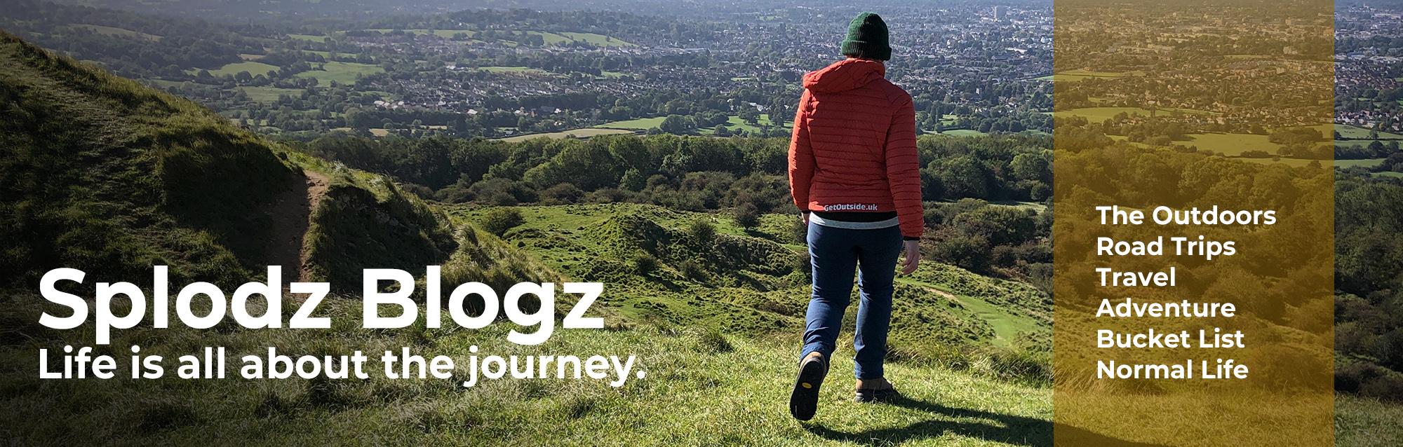
A hike up Aberedw Hill and Wylfre Hill near Builth Wells in mid-Wales – a day of wide skies, quiet summits, and an unexpected detour.
Away from the National Parks, there’s something about hiking in mid-Wales that invites a slower kind of noticing. On the middle day of my Quirky Stay near Builth Wells, I found myself drawn to the hills east of the town – Aberedw Hill and Wylfre Hill – two grassy summits that promised height without drama, solitude without remoteness. I’d scanned a dozen possible routes, but this one stood out: a magazine-curated loop that would keep me on the tops for most of the day, away from the crowds, and close to the kind of landscape I love.

It was early August, and the weather was playing its part; breezy, clear, and cloudy. My sleep at Celtic Woodland Holidays had been particularly good, and I’d woken up refreshed and ready to hike. I set off with no time goal other than being back before dinner – I had the benefit of time and a desire to spend as much of it outside as possible.
From the start, it felt like a walk stitched together by small joys: big views within just a few steps from the car, a tea break near a trig point, even the way the ferns grew without obstacle. I didn’t see another walker all day. Just sheep, a (somewhat skittish) horse, and the occasional buzzard tracing circles overhead. It was the kind of hike that leaves you feeling both stretched and soothed; earned tiredness, quiet satisfaction, and a sense of having spent the day exactly where you were meant to be.

Watch the Video
Look, I know Aberedw Hill and Wylfre Hillsaren’t headline-makers. They’re not even really in the heart of the Cambrian Mountains; they sit quietly in the Radnorshire uplands, watching over the Wye Valley and the folds of the Edw. But… let me tell you about my day there, and why they’re worth adding to your to-hike list.
If you’d like to see this hike in motion – complete with a few breathless hilltop moments – the middle ten minutes or so of the below video captures it all. Made for my Quirky Stay at Celtic Woodland Holidays, it includes a full tour of the Derw cabin with a generous slice of the day hike through the Welsh hills. I’m still finding my rhythm with video, making and sharing, but it’s a playful companion to these written pieces here on Splodz Blogz: part memory, part meander. Join me onscreen for the ramble and the views…
The Quiet Reach of the Radnorshire Hills
Aberedw Hill and Wylfre Hill sit in the southeastern reaches of the Cambrian Mountains, though they’re often considered part of the Mid Wales Uplands or Radnorshire Hills rather than the core Cambrian range. They’re fringe dwellers: not quite central, but still shaped by the same ancient geology and glacial history. These aren’t dramatic peaks – I couldn’t tell them apart from a distance like those in Bannau Brycheiniog (Brecon Beacons) or the Black Mountains down the road. They’re slow hills, sheep-folded and bracken-soft, rising gently above the Edw Valley and watching over a patchwork of commons and old tracks.
From the summit of Aberedw, the land unfolds in quiet grandeur. The Wye Valley winds below, silver and sinuous, with Builth Wells tucked into its curves. To the southeast, Hay Bluff and the Black Mountains form a distant wall of ridged silhouettes. Wylfre Hill, just one rise over, feels like a quiet sentinel – it’s less storied, perhaps, but no less atmospheric.
These hills are part of a wider scene including Rhulen Hill, Llanbedr Hill, Red Hill. All grassy, all grazed, all stitched with the kind of paths that invite slow walking without realising how far you’ve travelled. It’s a landscape that doesn’t shout. It hums. And if you pause long enough, you’ll hear it; weather, myth, and memory converging in the creases of the hills.

Getting Started up Aberedw Hill
I parked up in a lay-by where the A481 meets the B4567, just outside Builth Wells and a little north of Aberedw (grid ref SO061518). From there, the route dipped briefly into the valley before launching straight up the hillside: a 280m-ish climb over a mile or so, not outrageous, but enough to get my legs and lungs properly involved. I’m not at peak fitness right now, and honestly, that’s part of why I hike – to feel my body working, to remind myself I’m still here.
The ascent followed an old quarry access road, switch backing its way up until the track gave way to open hilltops. The landscape immediately stretched wide and wild. I could make out peaks in the Black Mountains, including Hay Bluff, familiar from last year’s hike, now a distant anchor on the horizon.
The top was everything I love: purple heather, big skies, and that feeling of being small in a vast, generous landscape. The walking was easy once I’d done that initial climb, and the sense of space was immediate and grounding. I said it in the video, but I’ll say it again here – this is exactly the kind of place I feel most myself.
One surprise: how dry everything was. The Ordnance Survey map warned of marshy ground, but even Pen-waun Pool was cracked and empty, sheep nosing around for water. Luckily, I’d brought plenty of my own (although not enough to share with the curious sheep). The land felt parched, but still welcomed me in.

The Route and the Day
This route was originally curated by Country Walking Magazine, so they’re to thank for sparking this particular day out. I’ve embedded their version of the walk below, so you can take a closer look, and maybe add it to your own to-hike list. That said, what I actually walked wasn’t quite what they plotted. A wildly overgrown path led to a detour I hadn’t planned, but one that added its own flavour to the day. Keep reading to find out where I changed plans, and decide for yourself whether to follow the route as it is, or embrace your own improvisation.
The route should have been 9.5 miles, but thanks to the detour (and a few extra pauses to enjoy the view), I clocked 11.3 miles in total, taking just under five hours. The terrain was mostly easy-going, with a steep start and finish that bookended a gently undulating middle section – my favourite kind of walking. The fern jungle was the only real challenge, and even that was more of a navigational puzzle than a physical one.
Weather-wise, it was spot on: cool and sunny, with cloud rolling in just enough to keep things interesting. It looked like it might rain at one point, but it held off, leaving me with far-reaching views almost the entire way. Honestly, such a good route. One I’d happily recommend to anyone looking to explore this corner of mid Wales, especially if you’ve got the time and freedom that a Quirky Stay can offer.
Download file for GPSSee the full route on OS Maps.
Aberedw Hill
The path across the hilltops was easy to follow, and I could see the trig pillar crowning Aberedw Hill from a good distance. There was no need to check the map, as there was a clear line through heather and ferns, with the land gently guiding me forward. Within three miles or so of setting off, and just over an hour in, I was at the summit. Picnic blanket out (my Pacmat Patch, naturally – get one!). Flask of tea in hand. My happy place.
Aberedw Hill rises to 451 metres above sea level—a quiet Marilyn tucked into the Radnorshire uplands. Its summit is marked by an old trig pillar and what’s likely a Bronze Age tumulus. The hill sits within a patchwork of historic commons and mountain pasture, once farmed and quarried, now grazed and wandered. Over 250 archaeological features have been recorded here, from prehistoric cairns to medieval house platforms and post-medieval field systems. It’s a landscape of long memory, where bracken hides the remnants of vanished cottages, and old boundary walls still shape the sheep’s slow circuits.
And then there’s the folklore, always a favourite of mine. St Cewydd, Wales’s patron saint of rain (a sort of Welsh St Swithin), is said to have walked this hill regularly, passing via Maengewydd (Cewydd’s Rock) on his way to Disserth. His hermitage was reputedly in Llywelyn’s Cave, near Aberedw itself, which is also said to be the final refuge of the last sovereign Prince of Wales. It’s a place of stories, for sure – and whether the threads are true or not, I don’t really mind.

A Fern-Related Detour
Knowing I had all day to hike, I lingered atop Aberedw Hill with my flask of tea and a few crunchy carrots, soaking up the view before setting off again. My route looked straightforward enough: down through the fern-filled valley, then up the other side to summit Wylfre Hill, where I hoped to find the perfect lunch spot.
At first, everything went to plan. The path was clear, winding through heather and then into fern, easy to follow and gently downhill. But as the elevation dropped, the fern seemed to rise in protest – taller and thicker with every step. Before long, I was wading through shoulder-high fronds, then chest-high, then towering overhead. It felt like walking through a jungle. The path vanished beneath the greenery, and no matter how often I checked the OS Maps app to see where the path should be, I couldn’t pick my way through. I was exactly where I should have been, but the landscape had other ideas.
Just shy of Pen-blaen-Milo, I admitted defeat. Not because I was in danger, but because I was deeply uncomfortable. Claustrophobic, disoriented, and frankly fed up. I retraced my steps, tried a few alternatives, and eventually forced my way to a clearing. From there, I skirted a fence line and picked up a more obvious path, heading the wrong way, but at least heading out.
Once free of the fern, I studied the map again and chose a longer, flatter route around to Wylfre Hill. It added a mile and a half in total, but it was faster, calmer, and stunningly beautiful. A detour well worth taking.

The Importance of Map Reading
This wasn’t a dramatic moment, but a quiet decision to change course when the terrain stopped feeling okay. And I could do that confidently because I know how to read a map.
I’m no navigation expert, but I understand how to plan a route and adapt it when things shift. That skill meant I could reorganise myself on the fly, rerouting without panic or guesswork. The original path probably was there, hidden under the fern, but I chose to stop searching and go another way. That choice gave me back my comfort, my rhythm, and my joy.
If you love to walk and haven’t yet learned to read an OS Map properly, I can’t recommend it enough. There are brilliant guides on the Ordnance Survey website, and plenty of courses out there if you prefer – my friend Anna runs some that are worth a look. It’s a skill that turns a hike into an adventure you can shape for yourself.

Wylfre Hill
All that fern-related excitement meant I didn’t quite make it to Wylfre Hill before deciding it was time to tackle the pork pie I’d packed for lunch. I found a grassy knoll with a view of both summits – Aberedw behind me, Wylfre ahead – and settled in for a shoes-off break, buzzards circling overhead in search of their own midday snack. It was one of those moments that makes hiking feel like a kind of gentle rebellion: slowing down, tuning in, letting the landscape hold me for a while.
From there, it was a short descent and then a steady climb to my second trig pillar of the day, perched at 410 metres above sea level. Wylfre Hill is a gentler rise than Aberedw. The wind was much stronger here; definitely not a lunch spot contender after all. The path was clear (phew!), the walking easy, and the views were wide and generous. It felt quieter here, less storied perhaps, but still full of presence.
While Wylfre doesn’t boast the same archaeological density as its neighbour, it shares the same geological and cultural backdrop, shaped gradually by glacial action, pastoral rhythms, and the slow layering of human memory. It sits not too many miles from Radnor Forest, where legend says the last dragon in Wales sleeps beneath the hills, guarded by four churches dedicated to St Michael. So maybe Wylfre is a quiet sentinel, watching, waiting, holding on.
Okay, I’m reaching, I know that. But it’s part of the same story: commons, sheepfolds, old tracks, and the kind of folklore that lingers in those who wander in these parts.

A Dry Ford and Chatty Local
Retracing my steps from Wylfre Hill, I passed the grassy knoll where I’d eaten lunch, now warmed by the afternoon sun. A skittish pony appeared from the heather, curious enough to follow me for a few minutes before deciding I wasn’t worth the effort and trotting off for a snack. The ground underfoot was still bone dry – sandy, even – for terrain marked as marshy. At one point, the OS Map insisted I should be crossing a ford, but there wasn’t a hint of a stream, let alone anything resembling a water crossing. It was a reminder of how the dry spring and summer has shaped the land, despite the recent rain.
The descent to Neuadd Fach was steep, one of those drops that makes you grateful for proper hiking shoes and a bit of caution. I’ve hiked steeper, sure, but this one packed a punch. I wouldn’t fancy it in the wet, and I was very glad I wasn’t climbing up!
Down in the valley, I passed a small cottage and found myself in conversation with a local man waiting for a friend. They’d met on a Rotary Exchange as teenagers and hadn’t seen each other in 42 years. His excitement was infectious, and though I’m not usually great at small talk, I was glad I stopped to say hi. It was a pleasure.
The final stretch followed a quiet farm track, then a country lane, looping me back to the path I’d started on and finally to my car in the lay-by. A full circle, in every sense.

Hiking Reflections
This was, without question, a most excellent day out. A circular route that took me up onto Aberedw Hill, across the valley (with that fern-related detour), and on to Wylfre Hill before looping back to the start. It was a walk of wide skies, purple heather, and sandy paths where streams should have been. I watched buzzards overhead, met a skittish pony, and had a lovely chat with a stranger who reminded me how much joy can live in a single moment.
The weather was perfect – cool enough to keep moving, warm enough for shoes-off tea breaks. Even the retreat from the fern jungle didn’t dampen my spirits. If anything, it added to the story. I felt confident rerouting, grateful for my map-reading skills, and glad to be in a landscape that welcomed wandering.
I’d absolutely recommend this hike to anyone looking to explore this quieter corner of mid Wales. It’s not dramatic, but it’s deeply satisfying – full of texture, history, and the kind of peace that settles in my bones and lasts all week.
And of course, it was made all the better by the Quirky Stay that gave me the freedom to take my time. Staying at the Derw cabin meant I didn’t need to rush back, didn’t need to clock-watch. Just me, the hills, and a whole day to walk. That’s the kind of gift I’ll always be grateful for. Do go and read that post (and watch the video) if you haven’t already.

Want to follow this route (the one I planned to hike…)? You’ll find it on OS Maps…
Don’t have a subscription to OS Maps? Use OSCHAMPS to claim three months free premium access to the app (affiliate link, code works best via the mobile app) – it’s a game-changer for planning and sharing your hikes.
What do you think? Comment below...